Lot 1205
1205
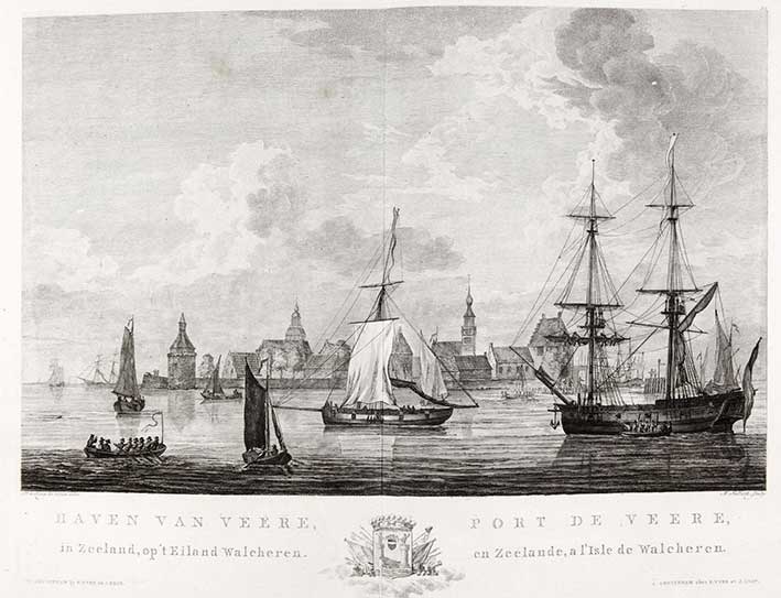
MARITIME HISTORY - TRAVELLING -- JONG, D. de. Atlas van alle de zee-havens der Bataafsche Republiek. Amst., J. Allart, 1802. (1) leaf and 28 fine double-p. Dutch harbour views by D. de Jong, etched/engr. by M. Sallieth. Fol. Cont. hcf., spine gilt and w. green label. (Rebacked w. use of old spine, some minor unprofessional colouring added to three plates, paper skilfully restored in places (espec. lower margin) and washed).
Strong impressions and fine etchings (2nd state (of 3)) with engraved captions underneath in Dutch and French of the harbours of Rotterdam, Delft, Amsterdam, Enkhuizen, Hoorn, Texel, Dordrecht, Middelburg, Brouwershaven, etc. Each view also being embellished with it's own engraved coat of arms in the centre of the lower blank margin of the plate representing the city depicted. Below the title is the address 'Te Amsterdam by P. Yver, J. Smit en Zoon, en F.W. Greebe'. Although the book was published in 1802, the drawings by Dirk de Jong were already made around 1780/81. Image size: 210 x 340 mm., plate size: 285 x 382 mm. - De Groot & Vorstman, 181-2; NHSM, 319 (calls for 27 plates).€ 3000
result € 0
Back