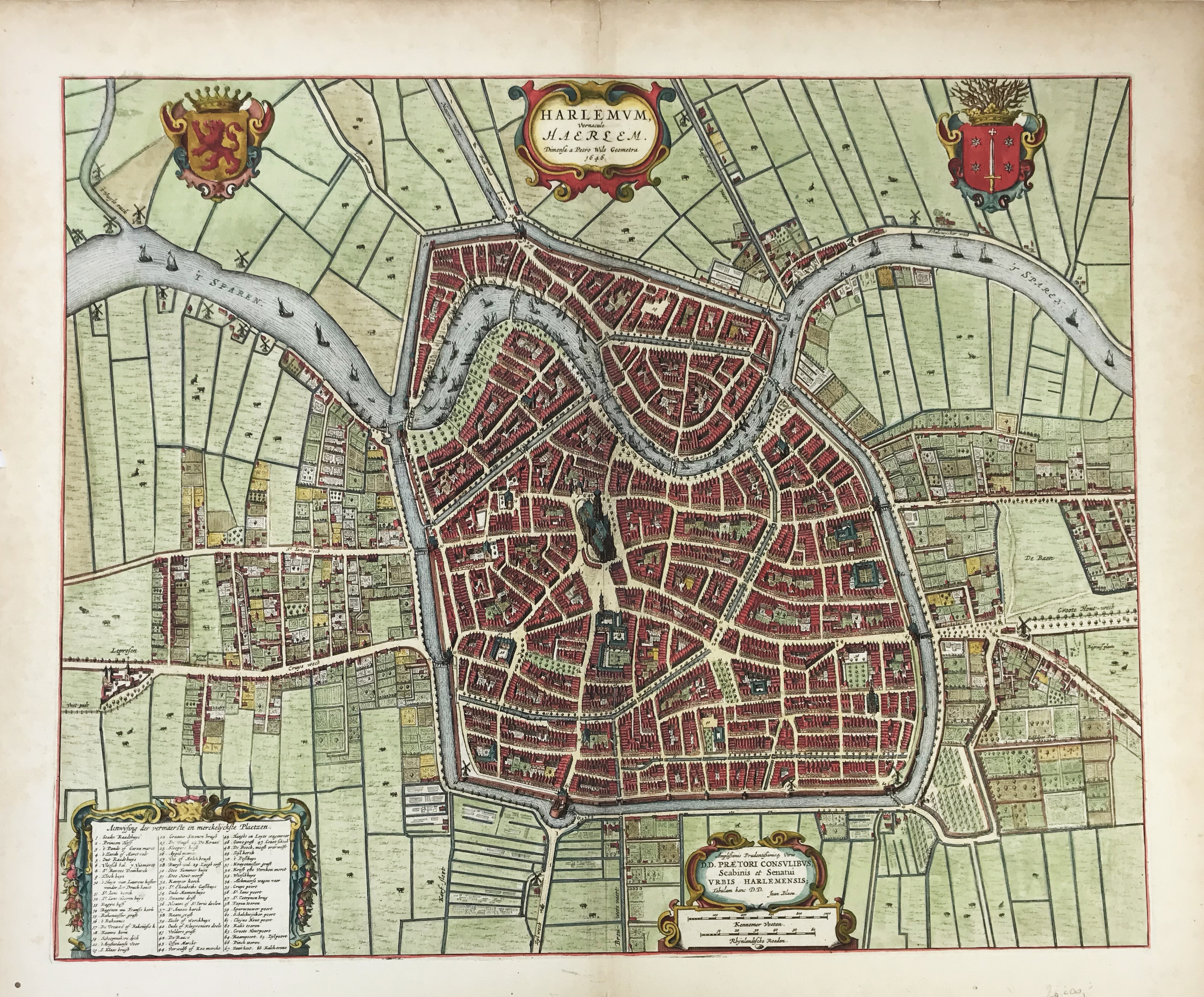
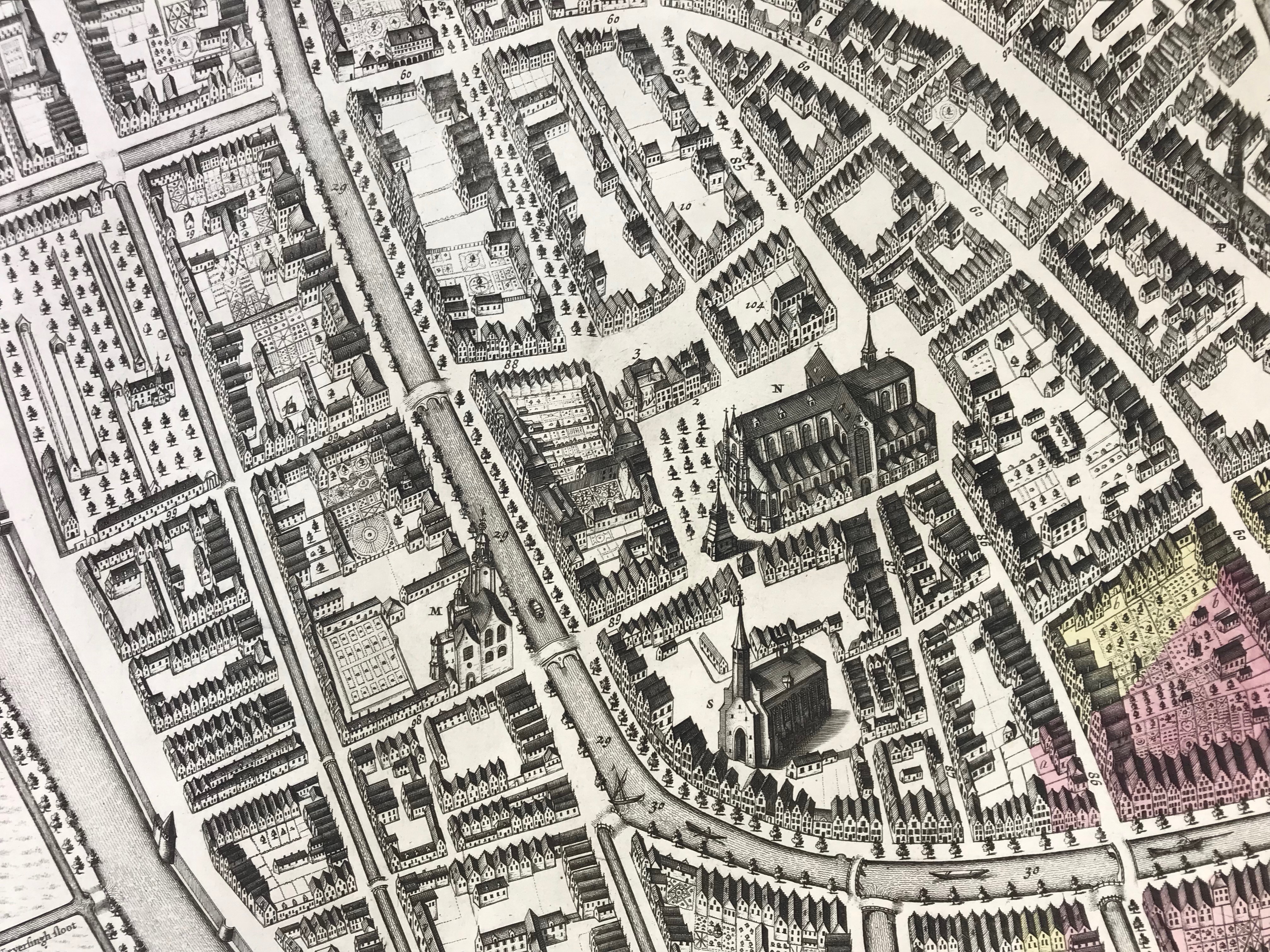
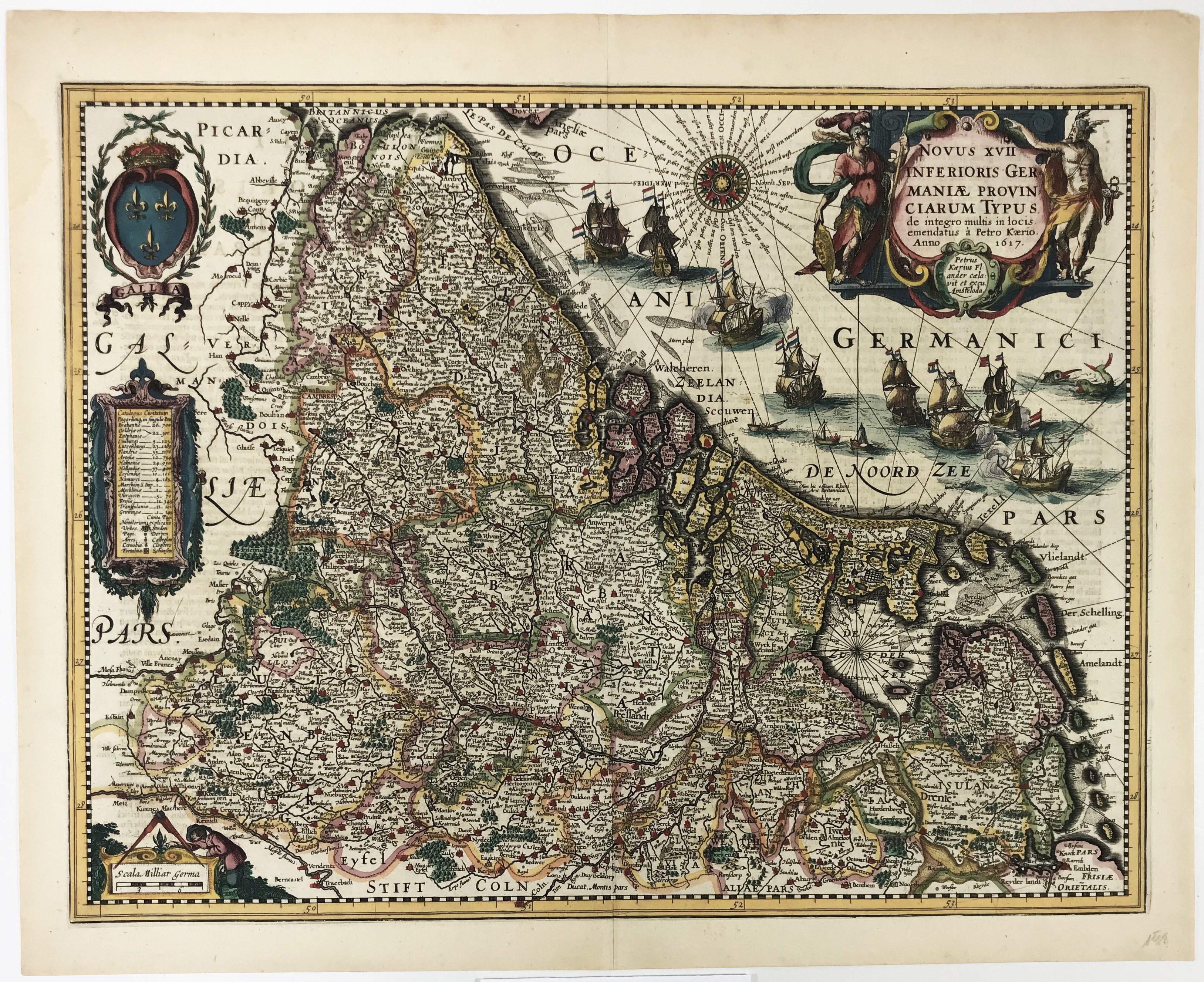
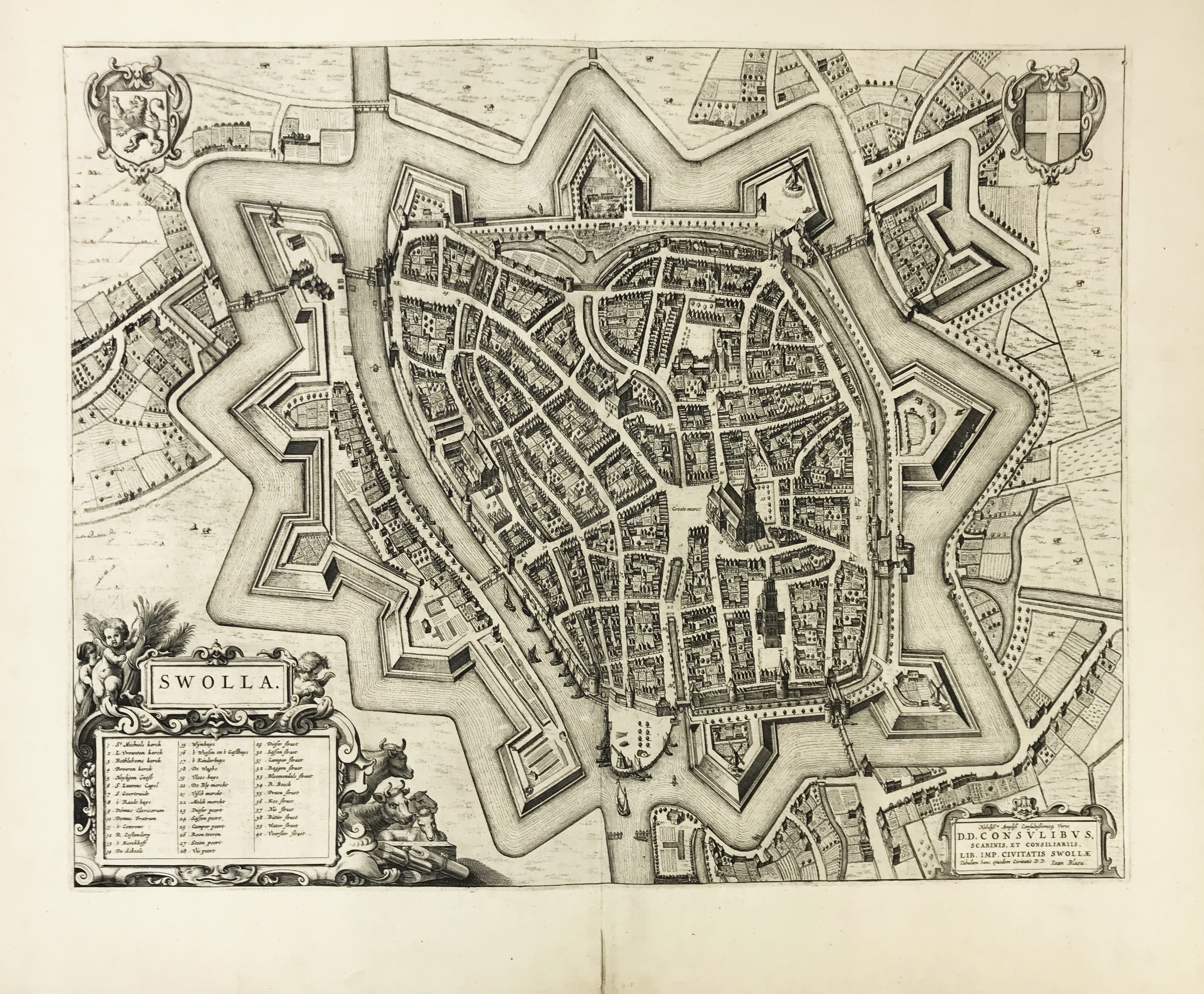
ASIA -- "ASIAE NOVA DESCRIPTIO". (Amst., Mercator-Hondius, c. 1620). 375 x 506 mm. Engr. map in cont. colouring w. 3 cartouches. (A bit browned, v° side w. several repairs, a bit dam. on centrefold and on a second vertical 'false' fold, tear visible in left outer corner, margins ample). Under passepartout.
€ 200
ASIA -- SRI LANKA -- "INS. CEILAN quæ incolis Tenarisin dicitur". (Amst., Mercator-Hondius, c. 1630). 347 x 500 mm. Engr. map in cont. colouring w. 3 cartouches and compass card. Tipped in under passepartout. (Skilful rep. of 2 small tears in image on v°-side, but in good condition w. ample margins).
€ 150
CENTRAL EUROPE -- "BOHEMIA Newly described by John Speed Anno Dom: 1626". (London), Roger Rea the Elder and younger, (c. 1665). 420 x 535 mm. Engr. map in cont. colouring w. border decorations (comprising of 7 town views and 10 puppets). (Left lower outer margin short, but else in fine condition and in nice colouring).
LOW COUNTRIES -- "ANVERPIA, nobile in Brabantia oppidum". (Cologne, Braun & Hogenberg, 338 x 480 mm. Engr. bird's eye view of the city of Antwerp, seen from the South, in cont. colouring. W. 2 cartouches and 2 coats of arms. (Split on centrefold rep. on v°-side, image slightly soiled following centrefold, but in good condition).
LOW COUNTRIES -- "COMITATUS HOLLANDIA. 't Graefschap Hollandt." Amst., W. Jansz. (Blaeu), 1608. Cold. engr. map, richly embellished, i.a. w. 3 cartouches (2 inscribed), 2 compass cards, ships in full sail, and a row of 32 cold. city arms in the lower margin. 400 x 490 mm. (Laid down and skilfully remargined).
€ 800
LOW COUNTRIES -- "FLANDRIA". (Antwerp, Ortelius, 1572-74). 390 x 508 mm. Handcold. engr., oval shaped map. w. inscribed cartouche, scale indicator and compass card.
€ 300
LOW COUNTRIES -- "FLISSINGA". (Guicciardini, c. 1610). Engr. plan of the city in bird's eye view w. index in Dutch in the right upper margin, cold. by hand. 220 x 290 mm. (Colouring faded). First state. Guicciardini Illustratus, Vlissingen 2.1. -- Added: "DIE BELEGERUNG VON MIDDELBURG". (Braun & Hogenberg, c. 1595). Siege of 1574 by the Spanish troops of the city in bird's eye view w. caption in German engr. underneath, faintly cold. by hand. 215 x 295 mm. -- (2).
€ 70
LOW COUNTRIES -- "GERMANIA INFERIOR. Gallia Belgica dicta, continens Hispaniarum Regis Provincias Septentrionales. Formis Hæredum Gerardi de Iode". (Antwerp), Heirs of G. de Iode, (1593). Handcold. engr. map w. inscribed cartouche and scale indicator. 345 x 437 mm. (Margins trimmed to image, laid down professionally, unobtrusive cracks in image on/next to centrefold).
€ 600
LOW COUNTRIES -- "HARLEMUM, Vernacule Haerlem". (Amst.), J. Blaeu, (c. 1650). Handcold. engr. bird's eye plan after P. Wils w. 2 coats of arms, and 3 inscribed cartouches. 465 x 570 mm. (A bit age-toned, left blank margin w. 4 small splits and small hole, but in good condition and w. ample margins).
LOW COUNTRIES -- "LUGDUNUM BATAVORUM Anno 1670". (Amst., 1674). Plan of Leiden by C. Hagen in 4 engr. plates, each 485 x 610 mm (tog. 97 x 122 cm when conjoined). W. 4 elaborate cartouches in each corner, 1 of which has an index on buildings. -- Tog. w. 3 engr. plates, each c. 360 x 600 mm, representing the arms of Leiden, flanked left and right by 2 coats of arms of Leiden burgomasters: Van der Meer, Meerman, Van Groenendyck and Schuil. (Clean and w. ample margins, but w. some creasing and splits on blank margins in places).
€ 1200
LOW COUNTRIES -- “NOVUS XVII INFERIORIS GERMANIAE PROVINCIARUM TYPUS de integro multis in locis emendatus (…)”. Amst., P. Kaerius, 1617 (=1622). Handcold. engr. map with scale indicator, 2 inscribed cartouches, ships, sea monsters, coat of arms and compass card by Petrus Kaerius. 385 x 504 mm. (Slightly age-toned, but in fine condition w. ample margins).
€ 500
LOW COUNTRIES -- "SWOLLA". (Amst.), J. Blaeu, (c. 1650). Plain engr. bird's eye plan of Zwolle, w. 2 coats of arms and 2 cartouches. 415 x 525 mm. (Split on fold rep. at v° side, but in very good condition w. ample margins). -- Added: "STEENWIICK". (Amst.), J. Blaeu, (c. 1650). Handcold. engr. bird's eye plan of Steenwijk w. 2 coats of arms, scale indicator and inscribed cartouche. -- (2).
LOW COUNTRIES -- "XVII PROVINCIARUM INFERIORIS GERMANIÆ: nec non totius tractus Rheni ultra Francofurtum (...)." Amst., C.J. Visscher, 1630. Handcold. engr. map by A. Goos, w. 2 inscribed cartouches, 2 compass roses, ships and coats of arms of the 17 Provinces. 436 x 547 mm. (Laid down and remargined professionally, w. unobtrusive, skilful additions in manuscript and colouring (i.a. in lower left and right border)).
SEA CHARTS -- AMERICA -- "PASKAARTE van 't Zuijdelijckste Deel van America v. Cabo St. Antonio, tot Caep de Hoorn, (…)". Amst., H. Doncker, n.d. (c. 1660). Handcold. chart w. inscribed cartouche, ships, scale indicator and compass card, depicting the Atlantic coastline from Rio de la Plata all the way down to Cape Horn. 430 x 536 mm.
SEA CHARTS -- ATLANTIC -- "NIEUWE PASKAERT Vande Gheheele Westersche Scheep-vaert. Op Nieus uyt Ondervindinghe van Schrandre Stierlieden Naaukeurigh Geteeckent en samen gebracht". Amst., J. v. Keulen, n.d. (c. 1681). Cont. handcold. chart w. a few elements heightened w. gold, w. 2 elaborate inscribed cartouches, and coat of arms, depicting the Atlantic coastline from the Netherlands all the way down to Gambia. 512 x 590 mm.
SEA CHARTS -- "DE CUST VAN BARBARIA, Gualata, Arguyn en Geneheo van Capo S. Vincent tot Capo Verde." N.pl., no publ., n.d. Handcold. engr. chart w. cartouche and compass card. 425 x 530 mm. Later edition (annotated '55' in lower right corner) without address, similar to Doncker's chart (cf. Koeman IV, Don 2 (10)). Showing part of the Iberian peninsula, the Canary Islands, Madeira, the Azores and Capo Verde. -- Added: "INSULÆ CANARIÆ, Alias Fortunatæ dictæ". (Amst., Blaeu, 1662). Plain engr. chart of the Canary Islands, Madeira and Porto Santo Island w. compass card, scale indicator, ships and inscribed cartouche. 390 x 504 mm. In very good condition w. ample margins, Latin text on v°. -- (2).
€ 80
SEA CHARTS -- FRISIA -- "BESCHRIJVINGHE van de zee Custen van Oost Vrießlandt, met allen ondiepten en bakenen. Orae maritimæ (etc.). 1584". (Leiden, 1586). 330 x 515 mm. Plain engr. sea chart w. 2 cartouches, compass card, ships and a sea monster by Joh. v. Doetecum after L.J. Waghenaer.
SEA CHARTS -- "GALLIÆ, BISCAJÆ et Gallissiæ Sinus/De Bocht van Vranckryck, Biscajen en Galissen". (Amst.), R. & J. Ottens, n.d. (c. 1720). Engr. chart of the coast of the Bay of Biscay, partly cold. by hand. W. large cartouche in the upper right corner, a smaller one in the lower centre and w. inset: "Le Port de Lorient" in the left upper corner. 490 x 560 mm. (A bit browned, traces of former framing along margins and on v°).
SEA CHARTS -- "HISPANIÆ, et Portugalliæ Maritimi tractus, à S. Andreo, ad Malagam/Pascaert van Spangie, en Portugal". (Amst.), R. & J. Ottens, n.d. (c. 1720). Engr. chart of the coast of the Iberian Peninsula, partly cold. by hand. W. large cartouche in the upper centre. 490 x 560 mm. (A bit browned, traces of former framing along margins and on v°).
SEA CHARTS -- "RUSSIÆ et NOVÆ ZEMLÆ MARITIMÆ". (Amst.), R. & J. Ottens, n.d. (c. 1720). Engr. chart of the Barents Sea w. parts of Russia, Lapland and Nova Zembla, partly cold. by hand. W. large cartouche dep. i.a. bear hunters. 490 x 560 mm. (A bit browned, traces of former framing along margins and on v°).
SEA CHARTS -- SRI LANKA -- "PASCAERT VAN 'T EYLANDT CEYLON, Voordesen Taprobana: (…)". (Amst.), G. v. Keulen, (between 1680 and 1700). Plain engr. chart w. inscribed title cartouche representing a camel and figures in regional costume, scale indicator, several vessels at sea, etc. 526 x 605 mm. (Laid down professionally, margins trimmed on/near plate edge, but in good and clean condition).
SPAIN -- HISPANIA (…) emendatis per observationes Sociorum Acad. Scientiarum, qua est Parisiis, per G. de L'Isle. Augsburg, M. Seutter, (c. 1735). Cold. map of the Iberian Peninsula. 540 x 620 mm. In fine condition. -- Added: smaller map of Spain by De L'Isle, dated 1705. -- (2).
VARIA -- COLLECTION of 4 engr. title-pages from atlases published by Mercator/Hondius (n.d.), Blaeu (1648), Janssonius (1652) and Doncker (1673). All cold. by hand, partly heightened w. gold. Largest 420 x 260, smallest 230 x 165 mm. 1 in passepartout.
VARIA -- "GERARDUS MERCATOR (&) IUDOCUS HONDIUS (...)." (Amst., J. Hondius, 1613). Handcold. engr. double-portrait, within architectural ornamental border depicting i.a. a sphere and 4 globes. 390 x 456 mm. (Centrefold strengthened on v° side, colour showing through at v° side, but in good condition and w. ample margins).
WORLD MAP -- "MAPPE-MONDE pour connoitre les progrès & les conquestes les plus Remarquables des Provinces-Unies, Ainsi que celles des Compagnies d'Orient et d'Occident, Et les Païs quelles possèdes dans l'un et dans l'autre Hemisphere". (Amst., Chatelain, 1719). Handcold. engr. map of the world represented in 2 hemispheres, w. lists of all the conquests in all corners, ships , the Dutch Lion, etc. 337 x 460 mm. (Slight discolouring to centrefold, small split on fold in blank margin, but in good condition w. ample margins).
€ 240